US Robots Renew MH370 Deep‑Sea Hunt
A high‑stakes second chance at sea
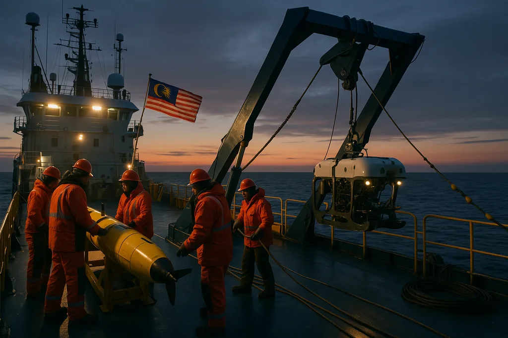
This month Malaysia confirmed it will restart the deep‑sea search for Malaysia Airlines Flight MH370, scheduling the operation to begin on 30 December — more than eleven years after the Boeing 777 vanished on 8 March 2014. Instead of surface ships alone or ad hoc debris hunts, the new effort will lean on a fleet of US‑built ocean robots: autonomous and remotely operated systems that can map, image and inspect the deep seafloor at resolutions unavailable on the first searches.
The renewed operation
The announcement marks a symbolic and technical relaunch. In earlier years governments, commercial contractors and volunteer teams scoured vast swathes of the southern Indian Ocean with towed sonar and ships, and a private company mounted a robotics‑based search in 2018. Those efforts established the scale of the challenge — huge distances, deep water and extremely rough, poorly charted seabed — and they returned important lessons about how to use robotic assets efficiently. This new campaign will attempt to apply the latest generation of undersea robotics and sensor processing to a narrower, refined search area informed by the accumulated oceanographic and satellite analyses of the last decade.
Undersea robots and sensors
What people mean when they say “ocean robots” is a spectrum of vehicles and instruments. At the front end are autonomous underwater vehicles (AUVs): torpedo‑shaped robots that preprogrammedly glide meters above the seabed, sweeping large swaths with side‑scan sonar and multibeam echosounders to create high‑resolution imagery and bathymetry. Where an AUV maps a target, a remotely operated vehicle (ROV) can be sent down on a tether for live video inspection and sampling. Complementing those are towed synthetic‑aperture sonar systems for fine‑scale imaging, magnetometers to detect ferrous wreckage, and chemical sensors that can seek traces of aviation fuel or hydraulic fluids.
Technically, the advantages are straightforward: robots can operate far deeper than human divers, stay under for long hours without risk to crews, and fly consistent, repeatable survey patterns that reveal subtle anomalies in otherwise chaotic terrain. Modern systems also carry higher‑bandwidth navigation suites — inertial navigation corrected by Doppler velocity logs and acoustic positioning — that reduce the drift and location uncertainty that plagued earlier surveys.
Technical challenges of deep‑sea forensics
Despite advances, finding a wreck at several thousand metres depth remains enormously difficult. The Indian Ocean in the search zones is not a flat abyss: it's a jumbled landscape of ridges, canyons, and talus slopes that scatter sonar returns and hide debris within complex topography. Side‑scan sonar produces images that must be interpreted by experienced analysts; rocks, methane seeps and anthropogenic litter all produce echoes that can mimic aircraft fragments.
Endurance and coverage are a second constraint. A single AUV run covers a limited corridor — tens of square kilometres at most — and battery, sensor range and the time it takes to recharge or retrieve vehicles impose practical limits on how much area can be searched in a given season. That drives a two‑stage approach commonly used in deep searches: broad‑area, lower‑resolution mapping to find targets of interest, followed by focused, high‑resolution passes and ROV inspection of promising anomalies.
Finally, the evidence profile for aircraft is variable. Some debris fields are widely scattered; in other cases, a mostly intact fuselage yields acoustic traces of on‑board recorders for only a short time. Physical artifacts — composite fragments, fasteners, paint — are the most durable clues, but recovering them in deep water is slow and expensive work that requires precise targeting.
What robots add to the search
In the hands of experienced teams, modern robots change the cost‑benefit of these tasks. Autonomous vehicles can generate detailed bathymetric maps that were simply unavailable during the initial multinational search, helping planners eliminate false leads quickly. Image processing and machine‑learning tools are increasingly used to flag likely wreckage signatures in sonar mosaics, prioritising anomalies for direct inspection. Magnetometry can reveal metallic concentrations under sediment where optical sensors cannot see. Taken together, these capabilities make the hunt more systematic: fewer square kilometres missed, faster triage of contacts, and a clearer chain from mapping to recovery.
Human stakes and politics
The technical ambition sits beside powerful human and political imperatives. Families of the 239 people on board have spent more than a decade without definitive answers. For aviation authorities and investigators, a confirmed location of the airframe would allow analysis that could resolve lingering questions about the flight’s last minutes, improve safety recommendations for long‑range tracking and influence how international search duties are coordinated in future incidents.
At the same time, any restart of the search carries political sensitivity. Previous efforts required cross‑border coordination — diplomatic clearances, shared data repositories, tendering for specialist vessels and equipment. The involvement of US‑built robots signals both the technical level of the assets and the kind of international technical cooperation needed to mount such an operation.
The road ahead
The practical sequence for the coming weeks is likely to be familiar to oceanographers and salvage teams: a phase of mapping and reconnaissance using AUVs and towfish to build a high‑resolution seafloor picture, automated processing to identify anomalies, and then targeted ROV dives to visually confirm whether a sonar contact is wreckage. If the teams locate debris, recovery or sampling plans will be worked up; if not, the campaign will still refine the map of the search area for any future efforts.
Whatever the outcome, the renewed hunt underscores how robotic oceanography has moved from niche research into essential capability for forensic maritime work. Robots give investigators the ability to look where humans cannot, and to gather data that will be reinterpreted decades from now as methods and models evolve.
For families who have waited over a decade, and for the broader aviation and ocean science communities, the deployment of these robots represents a last, technologically sophisticated attempt to answer a very human question: what happened to MH370? The coming weeks will test whether modern undersea robotics — combined with refined search modelling and international cooperation — can finally close a chapter that has been open for far too long.